Newfoundland & Labrador
110,00 kr
Udsolgt. Fås i anden udgave.
ISBN
9781553419396
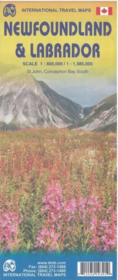
This is a double-sided map, with the island of Newfoundland on one side, showing all roads and villages, and the French islands of St. Pierre et Miquelon, as well as an inset map of St. John´s (the capital, and a fascinating city to visit), Scale 1:800.000.
The other side is unique. Labrador forms the wilderness part of the province. It has never been mapped properly by the government, so this is the first-ever map of this enormous and largely-unexplored part of Canada in scale 1:1.385.000. There is a land connection from Baie Comeau in Quebec north to Labrador City, and an east-west dirt road to Goose Bay via the huge power station at Churchill Falls, and ferry services along the coast. The rest is as wild as it gets.
The other side is unique. Labrador forms the wilderness part of the province. It has never been mapped properly by the government, so this is the first-ever map of this enormous and largely-unexplored part of Canada in scale 1:1.385.000. There is a land connection from Baie Comeau in Quebec north to Labrador City, and an east-west dirt road to Goose Bay via the huge power station at Churchill Falls, and ferry services along the coast. The rest is as wild as it gets.
| Forlag | ITMB publishing |
|---|---|
| Varegruppe | Maps & Guides |
| Ekspedition | SVB |
| Udgivelsesdato | 1. jan. 2015 |
| Sideantal | 0 |
| Bredde | 0 |
| Højde | 0 |
| Dybde | 0 |
| Vægt | 0 |
| Første udgave | 2015 |
| Oplagsdato | 1. jan. 2015 |
| Oplag | 0 |
| Udgave | 2 |
| Serie | International Travel Maps |
| ISBN-13 | 9781553419396 |
| ISBN-10 | 1553419391 |
| EAN | 9781553419396 |
| Sprog | Engelsk |
| Orignalsprog | Sproget kan ikke bestemmes |
| Illustreret i farver/sh | Nej |


