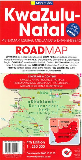
KwaZulu-Natal Road Map: Including Pietermaritzburg, Midlands & Drakensberg
128,75 kr
Desværre udsolgt fra forlaget.
ISBN
9781770268296
4th revised edition.
MapStudio's updated, easy-to-read KwaZulu-Natal Road Map at scale 1:250 000 includes GPS co-ordinates at major intersections and useful tourism contact details. The map features information boxes on activities and places of interest with lists of what to see and do. Clear map symbols for hotels, campsites, caravan facilities, places of interest, battle sites, historical sites, toll roads, shipwrecks, shopping and eateries. A detailed indexed street map of Pietermaritzburg. On the reverse side it features a large detailed map of Pietermaritzburg with a street index and a place name index for the main map. The KwaZulu-Natal Road Map along with KwaZulu-Natal covers Pietermaritzburg, Bushman's River Region, Drakensberg, Midlands, Battle Sites, the N3 route from Harrismith to Durban and Route 617.
| Forfatter | MapStudio |
|---|---|
| Forlag | Map Studio |
| Indbinding | Falset |
| Thema koder | Sydafrika, Turistkort |
| Varegruppe | Maps & Guides |
| Ekspedition | Scanvik |
| Udgivelsesdato | 1. jan. 2016 |
| Sideantal | 0 |
| Bredde | 0 |
| Højde | 0 |
| Dybde | 0 |
| Vægt | 0 |
| Første udgave | 2016 |
| Oplagsdato | 1. jan. 2016 |
| Oplag | 0 |
| Udgave | 0 |
| ISBN-13 | 9781770268296 |
| ISBN-10 | 1770268294 |
| EAN | 9781770268296 |
| Sprog | Engelsk |
| Orignalsprog | Sproget kan ikke bestemmes |
| Illustreret i farver/sh | Nej |


