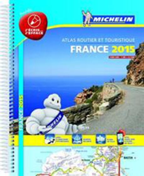
Michelin Tourist & Motoring Atlas France 2015
238,75 kr
Udsolgt. Fås i anden udgave.
ISBN
9782067200296
Michelin´s France 100% laminated A4 atlas offers, in addition of Michelin´s clear and accurate mapping, an enhanced view of your journey thanks to its scale 1/250,000. Convenient and easy to use thanks to its spiral bound cover, this atlas comes with extra-resistant laminated pages on which you can trace and erase your journey. The route planner as well as the time distance charts will help you plan and optimise journey. Michelin´s new safety alerts warns you about dangerous driving areas and zone subjet to tighter speed checks.
Michelin´s laminated France atlas also includes information on tourist sights, leisure facilities and scenic routes, as well as service areas to add pleasure and comfort to your journey. The revised 100% France atlas features:
- Scale: 1/250,000: for an enhanced view of your journey
- Extra resistant pages to draw/erase your journey as you go along - Key to map pages: to quickly access the region of your interest
- A complete town index: To easily indentify to destination of your choice
- Distance and time chart: to help you plan your trip
- 6 major town plans: Paris, Bordeaux, Lille, Lyon, Marseille & Nantes
- Michelin´s danger alers: to help you identify zones at risks for drivers and controlled speed areas
- In English language: Keys, indexes and information
The atlas is also cross-referenced with the famous Michelin´s Green Guide with tourist sights, scenic routes and leisure facilities.
| Forlag | Michelin |
|---|---|
| Varegruppe | Maps & Guides |
| Ekspedition | SVB |
| Udgivelsesdato | 12. nov. 2014 |
| Sideantal | 462 |
| Bredde | 0 |
| Højde | 0 |
| Dybde | 0 |
| Vægt | 0 |
| Første udgave | 2014 |
| Oplagsdato | 5. jan. 1 |
| Oplag | 0 |
| Udgave | 0 |
| Serie | Michelin Tourist & Motoring Atlas |
| ISBN-13 | 9782067200296 |
| ISBN-10 | 2067200291 |
| EAN | 9782067200296 |
| Sprog | Engelsk |
| Orignalsprog | Sproget kan ikke bestemmes |
| Illustreret i farver/sh | Nej |
Bøger i samme varegruppe: